Warning: Undefined array key "ssba_bar_buttons" in /home/ybv4ow29f690/public_html/hawaiipictureoftheday/wp-content/plugins/simple-share-buttons-adder/php/class-buttons.php on line 598
Warning: Undefined array key "ssba_bar_buttons" in /home/ybv4ow29f690/public_html/hawaiipictureoftheday/wp-content/plugins/simple-share-buttons-adder/php/class-buttons.php on line 598
Warning: Undefined array key "ssba_bar_buttons" in /home/ybv4ow29f690/public_html/hawaiipictureoftheday/wp-content/plugins/simple-share-buttons-adder/php/class-buttons.php on line 598
Warning: Undefined array key "ssba_bar_buttons" in /home/ybv4ow29f690/public_html/hawaiipictureoftheday/wp-content/plugins/simple-share-buttons-adder/php/class-buttons.php on line 598
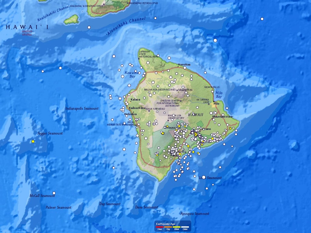
Not only does Hawaii’s Big Island have active volcanoes and surface lava flows, but it is also home to hundreds of earthquakes each year. Here, a map generated using the cool new tool provided by the USGS Earthquake Hazards Program shows all the earthquakes rated greater than a 1.0 in magnitude between June 1, 2012 and May 31, 2013.
In all there were 504 earthquakes bigger than a 1.0 in the last year–that’s more than 1 a day on most days. 51 of those were a magnitude of 3.0 or larger, and 3 were larger than a 4.0 (as indicated by the circle size).
Most of the earthquakes in Hawaii are barely felt, if at all. Those that are a bit bigger and a bit closer to the surface, though, definitely get our attention and remind us of just how small we are.


